Vancouver, BC – January 23, 2018
Geoscience BC revealed new project data at the AME Roundup conference today that will spark investment in mineral exploration and guide land planning in northern BC.
The Search Phase III project data highlights where mineral deposits may be with more accuracy than ever before. This will help the exploration sector, communities, First Nations, and governments to plan future land use and attract investment.
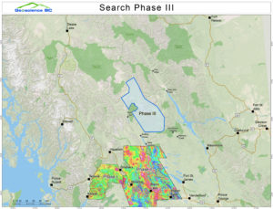
Search Phase III covers a remote 9,600 km2 area of north central and northeastern BC from the proposed Kemess Underground mine south to near Mackenzie. Helicopters equipped with ultra-sensitive magnetometers flew at a constant elevation of 80 metres for more than 40,000 km in the area – the equivalent of flying around the Earth. The data was then collated for release at this week’s AME Roundup conference.
Minister of Energy, Mines and Petroleum Resources Michelle Mungall welcomed the publication of the results. She said: “Globally, the increased demand for technologies like smart phones and electric cars is also increasing the demand for metals and minerals produced in British Columbia. Geoscience BC projects like this are critical to sparking exploration, discovery and ultimately the production of metals such as copper which are used for these items every day.”
Commenting on the release of the results, Geoscience BC Vice President of Minerals and Mining Bruce Madu said: “Search Phase III highlights new potential deposits containing metals like copper in a region that has been home to several mines in the past. It’s an exciting example of how new science can be used to drive investment and stimulate our economy.”
Search Phase III received $250,000 in approved funding support from Northern Development through the Economic Diversification Infrastructure program. The project provides data, which highlights where mineral deposits in the remote 9,600 km2 area of north central and northeastern BC from the proposed Kemess Underground mine south to near Mackenzie.
CEO Joel Mackay said: “The mining sector in British Columbia is gaining as commodity prices recover, creating new potential investment opportunities that will benefit communities across northern B.C. This data is critically important to informing mineral exploration decisions, and helping our region capitalize on global trends. We continue to value our partnership with Geoscience BC and commend them for their work on Search Phase III.”
Now that results are published, Geoscience BC will continue to work with First Nations and other communities in the project area to demonstrate how they can best use the new data. All results – from raw data to a series of summary maps – are available publicly for free.
The Geoscience BC team is available to discuss the data and other projects at AME Roundup Conference booth #324 in the Vancouver Convention Centre West until Thursday January 25th.
Accessing information
To view the reports and maps, visit the Search project page or view the information on Geoscience BC’s Earth Science Viewer online mapping application.
View project page and Earth Science Viewer.
About Search Phase III
- The data was presented at a talk entitled Sparking discovery and innovation opportunities: new Search Phase III geophysical data release on the Innovation Stage at AME Roundup from 10.45am on January 23, 2018.
- The $1.7 million project was funded by Geoscience BC and Northern Development Initiative Trust. Core funding for Geoscience BC is provided by the Province of British Columbia.
- CGG Canada Services Ltd carried out the helicopter survey on behalf of Geoscience BC, with quality assurance from in3D Geoscience Inc.
- Search Phase III follows on from previous phases of the Search project and Geoscience BC’s Targeting Resources for Exploration and Knowledge (TREK) project. Combined, these projects provide high quality and up-to-date data on potential mineral deposits within 65,100 km2 of northern and central British Columbia over the past 4 years. Projects like these are proven to bring new investment to the province.
Support for Search Phase III
The value of data from projects like Search Phase III has been confirmed by exploration sector representatives:
David Moore, President & CEO of Canadian junior mineral exploration company Serengeti Resources (www.serengetiresources.com):
“The Search Phase III data release by Geoscience BC today is just the sort regional data set that is most useful to the mineral exploration industry in the search for new mineral deposits in the province. The scale of this new survey provides plenty of opportunities for future discovery and is exactly the type of activity that organizations like Geoscience BC should be undertaking.”
Edie Thome, President & CEO of the Association for Mineral Exploration (AME) (www.amebc.ca):
“Association for Mineral Exploration (AME) members recognize public geoscience gives BC a competitive advantage. Data from Geoscience BC surveys like Search Phase III are proven to bring investment and lead to discoveries in British Columbia.”
About Geoscience BC
Geoscience BC is an independent, non-profit organization that generates earth science information in collaboration with First Nations, local communities, governments, academia and the resource sector. Our independent earth science enables informed resource management decisions. Geoscience BC gratefully acknowledges the financial support of the Province of British Columbia.
Media information:
Please direct all media enquiries to Richard Truman (truman@geosciencebc.com; 778 929 1662) or Candice Appleby (appleby@geosciencebc.com; 604 662 4147).
Representatives from Geoscience BC and NDIT are available for interview upon request. In addition, representatives from Association for Mineral Exploration and from Serengeti Resources are available to comment on how data from projects like Search Phase III is used. Please contact Geoscience BC to arrange interviews.
A brief overview of the Search series of projects is here: Search Project page
A video of the Search Phase III project is also available. If using content from this video please credit Geoscience BC: Search Phase III video
B-roll and images from the project are available here: B-roll and images